[sangar-slider id=”492″]
Dalam menyambut Hari Maritim di tahun 2020, Pusat Studi Sumberdaya dan Teknologi Kelautan mengadakan Pameran Virtual Hasil Penelitian dan Pengabdian Masyarakat Bidang Kemaritiman di Universitas Gadjah Mada. Pameran ini dilakukan secara daring mengingat masih melandanya pandemi Covid-19.
Link Menuju Pameran Virtual
Penelitian
ABSTRACT
This research was conducted in Maratua-Kakaban Islands, East Kalimantan,
Indonesia. This location was chosen because of its stable tectonic activity and its geographical
setting as the front most island in Indonesia. This location is also known as its tourism
destination and beautiful scenery. A small island like in Indonesia is prone to climate change,
especially sea level changes. This research is needed to formulate adaptation and mitigation of
sea level change in Indonesia. This research also important to understanding the global sea
change. This research also important from national sovereignty and coastal resources
management point of view. This research aims to: (1) identify water level changes evidence by
marine terraces analysis, cave morphology and speleothem; (2) define the highest and lowest
water level in Maratua Island, and (3) reconstruct the sea water level fluctuation during
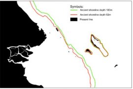
Holocene. Sea level fluctuation data were interpreted using marine terrace data, marine notch,
and cave morphology. The data were collected by field survey using profiling method to find
surface topography and measuring sea floor profile using echo sounder. Based on the field
measurement, there are major and minor marine terraces found in the ocean floor in 82 and
180 m depth (major), 155 and 205 m depth (minor). Marine terrace also found in +6 m above
present sea level. Below, marine notch was found covered with sediment.
ABSTRACT
Maratua Island is one of the islands of Berau District, East Kalimantan
which has great potential of natural beauty for tourism development. The area is a
carbonate reef built-up island or so-called karst island. This paper is an endeavor 1) to
unveil geomorphological and hydrogeological characteristics of the island, and 2) to
recommend Island development as a tourist destination. Maratua Island is a V shape
atoll with the open lagoon. The methods employed in the research were interpretation
of ALOS and LANDSAT TM image incorporated with image taken from drone, and
field survey. ALOS image and Alos-Generated DEM were used to identify and to map
the geomorphological features and landform. Field survey included cave exploration
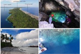
and mapping, as well as geomorphological and hydrogeological observation. Six
geomorphological units were found on the island, i.e., fringing reef, beach, marine
terrace, karst ridge, structural valley, and lagoon. Caves are also found in the karst
ridge and the coast as an inundated passage. Three structural depressions in the karst
ridge are other unique geomorphological feature in the area of which a marine lake
environment with jellyfish is inhabited. The island is typified by two different aquifer
units, i.e., porous media and fractured media aquifer. Porous aquifer lies on the beach
of Bohe Bukut area. Fractured-aquifer characterizes the other geomorphological units
in the area. Freshwater accordingly is found in the beach area with a limited amount.
Unfortunately, the groundwater in the marine terrace and karst ridge are saline.
Maratua Island has enormous potential for tourism destination development. The
major tourist activities in the area based on the geomorphological unit are snorkeling
and diving (in fringing reef and lagoon), hiking, cave exploration and marine lake
exploration and cave diving (in karst ridge and structural valley); recreation and picnic
(beach). The major limitation in the area is a shortage of freshwater resource and
limited land area. Limited water supply should be extracted from the beach area of
Bohe Bukut village. Groundwater extraction from the beach area of Bohe Bukut must
be for drinking water only. Supply of drinking water should be substituted from
collected rainwater or desalination from sea water and water in the cave. Restrictions
in the number of visitors and lodging development should also be considered.
ABSTRAK
Wakatobi merupakan salah satu kabupaten di Provinsi Sulawesi Tenggara yang
memiliki wilayah berbentuk kepulauan. Kabupaten Wakatobi memiliki visi
“Terwujudnya Surga Nyata Bawah Laut di Pusat Segitiga Karang Dunia”. Visi tersebut
merupakan cerimanan tekad pemerintah daerah dalam mengembangkan ekowisata
di Wakatobi. Wangi-Wangi merupakan pulau terbesar di Kabupaten Wakatobi yang
memiliki beraneka ragam potensi yang dapat dikembangkan sebagai potensi obyek
wisata. Tujuan dari penelitian ini adalah menginventarisasi keberagaman obyek
kebumian (geodiversitas) yang dimiliki oleh Pulau Wangi-Wangi melalui pendekatan
geomorfologis dan merekomendasikan potensi kegiatan ekowisata yang dapat
dikembangkan di pulau tersebut mendasarkan pada potensi geodiversitas. Penelitian
ini menngunakan metode interpretasi citra dan survei lapangan baik di daratan dan di
perairan laut. Hasil dari penelitian ini adalah peta geomorfologi sebagai informasi
geodiversitas. Potensi ekosiwisata diidentifikasi melalui survei lapangan berdasarkan
variasi bentukan geomorfologi. Berdasarkan kondisi geomorfologi, geodiversitas
Pulau Wangi-Wangi yang dapat dikembangkan sebagai obyek ekowisata adalah
karang tepi, laguna, pantai bergisik, pantai bertebing, teras marin, dan gua. Kegiatan
ekowisata yang dapat dikembangkan meliputi Swimming, Kayaking,Snorkeling,
Diving, Trekking, Climbing, Sightseeing dan Caving .
Keywords: Wakatobi,Pulau Wangi-Wangi, Geodiversitas, Ekowisata, Geomorfologi


